About Me

My photo
I first crossed the Atlantic in 1975 aboard 'Stormalong', a 28ft Wharram-designed catamaran. Back in the UK, Pete and I bought an ex 6-metre racing yacht, 'Sheila', living on her for 4 years. Wanting to do more and go further with a boat we could completely trust, we built 'Badger' - the best boat in the world - sailing her 110,000 miles, into the Arctic and the Antarctic, around the Atlantics North and South and into the Baltic. She had junk rig - the only rig I ever want to cruise with. Pete wanted to build again - a 38 ft junk-rigged catamaran, 'China Moon' - which he designed. But before the project was finished, we went our separate ways. A year later I joined Trevor Robertson aboard his 35ft 'Iron Bark'. We explored the Canadian Maritimes, crossed the Atlantic twice, wintered in Greenland and crossed the Pacific to Australia and New Zealand. I fell in love with NZ and jumping ship, bought my own boat while Trevor carried on voyaging. I put a junk rig onto ‘Fantail’ and, having decided that N Island offered better cruising opportunities than S Island, sailed up there in 2012. Looking for a boat to see me out, I am now building a 26ft, wood/epoxy junk in Whangarei.

Monday, 21 November 2016

Guy Garey from Dunedin, sent me the following, which would be very useful to people circumnavigating New Zealand this summer.  Or any other summer for that matter!

Going S from Banks Peninsula and its many harbours (the biggest being Akaroa - translated from Maori as 'Long Harbour'), you can count the decent havens on just a few fingers: Timaru (rather industrial), Oamaru (utterly not recommended unless you have excellent and up-to-date local knowledge), Dunedin, the Nuggets (a peninsula one can shelter behind), Waikawa (entrance as per Oamaru), perhaps Tautuku, and certainly Bluff . Bluff can have serious tides, as the entrance drains a large estuary. Call Mary on VHF channel 61 or 63 to get up to the minute recommendations. Hey, even (maybe even mostly) the fishermen check in. It is the smart thing to do. Once out of the shipping channels one can go lots of places to anchor, though with three metre (10 ft) tides (as I experienced) make sure you have clear water at low tide. 

Bluff is famous for  being both the furthest S one can go on 'mainland' NZ (which is actually Slope Pt, a few miles to the E) and for its seafood, especially its oysters. Blue cod, crayfish and paua (abalone near relative) are most often available, and the oysters during their own somewhat short season. If you like oysters and happen to be in Bluff when it is season, then don't be shy. All of NZ eagerly awaits the oyster season, and the smart eaters move fast. Bluff is also a good place to get repairs done, and avail one's self of safety gear (life raft, epirb, &c) because this is where the fishermen get theirs. 

If one goes S from Bluff, then Rakiura/Stewart Island is the next port of call. Get the latest Foveaux Strait conditions and weather from Fisherman's Radio before you cross the Strait, as conditions can change for the seriously worse almost instantly. One can also get flat calm conditions, as we did last time we went there. Even Cape Horn must have calms, one imagines. Stewart Island's waters are strewn with rocks; navigators pay attention! The nearest harbour/port/anchorage is Half Moon Bay, which sits before the settlement of Oban. Halfmoon Bay is protected from anything except a screaming NW'ly. Most things are available here, often not cheaply since transport is not inexpensive. In a small settlement such as Oban there are many 'the's', the foodstore, the pub, the wharf, &c. Yes, one can get lucky and tie up briefly to the wharf for taking on crew/passengers or water, but ask at the ferry dock first. At the 4 Square variety market one can obtain food, wine and beer (at surprisingly affordable prices) and other often-requested supplies. Both diesel and petrol and LPG are available at the petrol station. It seems that the only negatives are the prices... and the sandflies. The locals say that you get used to them (the flies), but I always return from Stewart Island with weeping bites where I scratched.  Distances around Oban are short, so you can walk from one end of the town to the other in an easy pace. Don't let that fool you though, because  Stewart Island is a big place; most of it in National Park. Close around the corner going E is Paterson Inlet, big enough to get rough conditions, but big enough also to have numerous nooks and crannies. I can recommend Kaipipi Bay (almost landlocked) for good shelter at the end of a narrow entrance and having nice, heavy mud. 

Dunedin has a wonderful harbour, the Otago Harbour, that it sits at the head of. The harbour offers excellent refuge from winds and seas of any direction, though getting through the narrow and somewhat winding entrance in a wind against tide situation can be a bit rough. The bays offering the best shelter are Portobello Bay (to the N of the hamlet of Portobello, which is on the S side of the Portobello peninsula), Latham Bay (directly at Portobello) and Broad Bay (still on the E side but another nautical mile further along).  

The trouble with the Otago Harbour is that it is tidal and shallow. At half to or after high water any boat with 2m or less should have no trouble at all... in the natural channels. Consult your chart and depth sounder fairly often, though if you do run aground most of the harbour is mud and sand so there is generally nothing more than pride affected. This is NOT the case with the main (W-side ship) channel which is lined with rocks, beginning on its E side where the middle ground cut/channel (from Kilgour Pt to Grassy Pt) is. 

Do remember that Dunedin is near enough to 46 degrees South latitude, hence it is often cold here. We do get warm and even hot temperatures, but Barbados it isn't. One nice thing about a higher latitude is the long light one may have before darkness. At summer's solstice one can still read the paper outside at 2200.

Dunedin was Aotearoa NZ's big city in the latter half of the 19th century, mainly due to the discovery of gold nearby in 1863 (+/-); and it remains an important center of urban life, supply and repair. The visitor's center in the Octagon (center of the city) is helpful for general & tourist information. For boat oriented things it would probably be a good idea to contact Read Marine (ph (03) 474 0871), who either have what you are looking for or can direct you in your search. 


Friday, 3 April 2009

SOUTH ORKNEYS AND GOUGH ISLAND
TABLE OF CONTENTS

Introduction
South Orkney Islands
Signy Island
Factory Cove, Borge Bay
Paal Harbour
Coronation Island
Shingle Cove
Robertson Islands
Matthews Island
Powell Island
Falkland Harbour
Ellefsen Harbour
Laurie Island
Scotia Bay
Gough Island
Transvaal Bay

Introduction


The following notes were made during a cruise to the islands in the summer of 1994-95 and are therefore in some ways out of date. At the time, we had no GPS, so the differences between chart datum and WGS 84 are not mentioned: judging from what other people have said, they can be considerable. Stick to traditional methods of navigation, once you are navigating to with half a mile.

The Antarctic Pilot, while more appropriate to small vessels than is usually the case with Admiralty Pilots, still has some gaps. I hope that these notes will help fill these and help when planning a cruise in this area.

When planning such a cruise, it is essential to appreciate that conditions in the Southern Ocean can be extreme and that you are very much on your own. Any yachtsmen sailing in these waters must be totally self-sufficient and prepared to extricate themselves from any eventuality. There are no rescue services and help should neither be sought nor expected from any of the few scientific bases. No-one should visit this area unless they are happy to sail without EPIRB or an SSB transmitter. Authorities are anyway unhappy at the thought of yachts sailing around this area without supervision: any request for assistance – however minor – is going to create more problems for those who follow on. It should also be remembered that it is impossible to replenish either stores or fuel.

Before making a decision, you should read The TOTORORE Voyage by Gerry Clark: it provides some very sobering accounts of how bad the conditions can be and no-one should venture down to this area without first reading this book. As well as being meticulously prepared for sailing in these latitudes, a yacht's ground tackle must be heavy and reliable. Hurricane force winds in apparently sheltered anchorages are not uncommon, and adequate ground tackle that will cope with these conditions is essential. This will mean that the anchors and chain might seem ridiculously oversized. Your life may well depend on it.

Weather conditions can change with extreme rapidity and a barograph is an enormously useful aid to weather forecasting.

The accuracy of available charts should not be relied upon. A number of rocks and shoals are unmarked and there are also large discrepancies in many areas between the position as indicated and that obtained by GPS.

The sketch charts included in these notes are just that. While every attempt was made to make them as accurate as possible, they should be treated with caution. This is not simply the usual disclaimer made in Cruising Guides – it is very genuine: most places were only ‘surveyed’ once and kelp, floating ice or poor conditions could all have contributed to errors being made. In anticipation of the metrication of the relevant charts, soundings are given in metres, to an approximate mean low water springs level. Heights are also in metres.

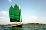
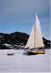
Of necessity, Badger features in nearly all the photographs of anchorages. Not only does this show where we anchored, but it also gives a scale to the picture.


Acknowledgements

Thanks to Russ Manning for his help and information.

Suggested Reading

The TOTORORE Voyage       Gerry Clark       ISBN 0-7126-2438-4
The Antarctic Pilot, NP9       H M Admiralty
Southern Ocean Cruising      Sally & Jérôme Poncet
Seabirds                                Peter Harrison       ISBN 0-395-33253-2
Ice Bird                                  David Lewis


Sailing off the South Coast of Coronation Island


South Orkney Islands

These islands are 420 miles SW of South Georgia and 240 miles E of the South Shetland Islands. They lie along the latitude of 60°40'S and thus come under the limits of Antarctic Treaty. This being the case, yachtsmen wishing to visit the area should first get permission from the appropriate department of their Government, if they are signatories to the Antarctic Treaty. The islands are very mountainous, with glaciers and snow covering much of them, right down to sea level. The scenery is grand and austere.

The islands were discovered on 6th December 1821, by George Powell, in the sealer, Dove, and Nathaniel Palmer on the James Monroe. A few sealers visited the islands, but nowhere near the numbers that went to the South Shetlands.

In 1903-04, Dr W S Bruce and other members of the Scottish National Antarctic Expedition wintered in Scotia Bay, Laurie Island. Among other scientific work, they set up a meteorological station. The Argentine Meteorological Department took over the station in 1904 and have maintained it ever since: the oldest continuously occupied base in the Antarctic.

A floating whaling factory started operations in the islands in 1907-8 and a shore-whaling factory was established in Factory Cove on Signy Island, in the early 1920's, but was only in operation for about four years.

In 1947, a base was built at Factory Cove by Falkland Islands Dependencies Survey (the forerunner of British Antarctic Survey) and has been continuously manned since then.

Awahnee, with Bob and Nancy Griffiths and a New Zealand crew aboard, visited the islands in February 1971, and was the first yacht to do so.

The yachts known to have visited the South Orkneys, up to Badger’s visit in 1995 are as follows:

1970-71     Awahnee    Bob and Nancy Griffiths and crew
1973-74     Ice Bird    David Lewis
1973-74     San Giuseppe Due    Giovanni Aimonegat and crew
1979-80     Momo     Charles and Jean-Marie Ferchand
1983-84     Damien II    Jérôme and Sally Poncet and family
1985-86     Damien II    Jérôme and Sally Poncet and family
1989-90     UAP Antarctica     Jean Collet and crew
1991-92     Diva ?
1993-94     Popeye ?
1994-95     Badger     Pete and Annie Hill

Charts and Pilot


The Admiralty chart, 1775, covers the whole of the South Orkney group. Included on it are large-scale charts of several anchorages. The latest edition was printed in 1988. It is believed that a new, metric chart is in preparation, but it is not known when this will be issued.

The Islands are covered by the Admiralty Antarctic Pilot, NP9, Chapter 4, page 150.

Note the caution on Chart 1775, that aerial photography in 1990-92 indicates that much of the coastline of the South Orkney Islands has a different shape from that charted and that off lying islands are in different positions. Additional inshore rocks and islands can also be identified on the photographs.

Ice

The islands are usually clear of pack ice in January, February and March. Obviously, conditions vary from year to year, but the months of December and April are also often clear of ice. However, on 23rd December 1991, the yacht Diva had to clear out of Factory Cove and was nearly trapped by ice drifting in. There are usually many icebergs stranded inside the 100-fathom line, around the islands and this may well give a good indication of their proximity if approaching in thick weather.

Bases

There are two bases in the islands, the Argentine base on Laurie Island, ‘Orcades’ and the British Antarctic Survey base on Signy Island.

Because few yachts visit this island, they are still something of a novelty to the base personnel and consequently, the welcome extended is much warmer than that apparently given to yachts at the more frequently visited bases near the Antarctic Peninsula.

Sites of Special Scientific Interest

There are four SSSI areas in the South Orkney Islands. These are: Moe Island (SW of Signy Island), Lynch Island (in Marshall Bay, off Coronation Island), part of the N coast of Coronation Island and the southern part of Powell Island. Full details of these SSSIs can be found in Sally and Jérôme Poncet's booklet, Southern Ocean Cruising.

Echo Sounders

Due to the greater density of the cold water, echo sounders will give a much-reduced performance. On Badger, it was noted that the range was only two-thirds of normal. Low air temperatures may mean that some models will not function reliably.


SIGNY ISLAND


60°42'S 45°37'W
Chart 1775: Approaches to Signy Island


This is a relatively low island, S of Coronation Island, with less snow and fewer glaciers than elsewhere in the South Orkneys and consequently, it is one of the few places where there is good walking ashore.

Factory Cove, Borge Bay


60°42'S 45°35'W
Chart 1775: Plan of Borge Bay

General


This is probably the best anchorage on Signy Island and, next to Falkland Harbour on Powell Island, one of the best in the South Orkneys.

At Factory Cove, at the S of the bay, is the BAS base, which is built on the site of the old whaling factory. The base has been continuously manned since it was built in 1947, but 1995 was to be the last time it is used for the winter. Thereafter it was planned that there would be a smaller, summer only base, occupied from November until April, with only eight people in residence.

Anchorage

The chart of Borge Bay is on a very large scale and Factory Cove is, in fact, quite small. Badger was anchored E of Knife Point, half way across the entrance in 7.5m. There was good shelter from all but the N and NE. Shelter from this direction could probably be obtained by anchoring S of the Mirounga Flats or E of Balin Point, at the N end of the bay.

Remarks

According to Russ Manning, the boatman at the base in 1994-95, Borge Bay can be subject to a NNE föhn wind, coming down from the Sunshine Glacier and that these can blow at up to full gale force. Föhn winds can generally be forecast by a ‘roll’ cloud over the Sunshine Glacier and a rise in temperature of a couple of degrees, which often tends to happen around midday. The föhn wind effect is usually fairly localised, with completely different conditions only a few miles away.


Factory Cove, Borge Bay


Factory Cove, looking N towards Sunshine Glacier


Paal Harbour


60°43'S 45°35'W
Chart 1775: Approaches to Signy Island

General

The next bay to the S of Borge Bay also provides anchorage. This bay is bordered by high cliffs to the N and W, with lower ground to the S. Strong winds from N and W may well give rise to williwaws. Depths in the bay are deeper than suggested by the chart, Approaches to Signy Island.

The inlet, at the NW corner of the bay, has reasonable anchoring depths, but it is very small and it would be necessary to take lines ashore in order to prevent swinging. There is a stony beach at the SW end of the inlet.

Anchorage

Anchorage was found in the cove at the S end of Paal Harbour, W of Rethval Point in 10m. There is sufficient swinging room to lie to a single anchor. At the head of the cove is a pebble beach.


Paal Harbour


CORONATION ISLAND
Shingle Cove


60°39'S 45°34'W
Chart 1775


Anchorage

On the W side of Iceberg Bay there is an anchorage in Shingle Cove. Anchor off the shingle beach on the SW shore in about 4m. Care should be taken to have swinging room to clear the underwater rocks to the N of the beach.

Remarks

On the shore are a colony of penguins and a BAS refuge hut.

This cove is a popular stop for the cruise ships.


Robertson Islands


60°46'S 45°09'W
Chart 1775

Between Steepholm Island and Skellig Island, there is a clear passage with a minimum depth of 50m observed. The rocks and the reef extending SE from Steepholm Island are much more extensive than shown on the chart. Keep S of this reef.

Matthews Island

60°44'S 45°09'W
Chart 1775

General

On the E side of this island is a bay, which appears to be the old crater of a volcano, Coffer Island being the core. The NW part of the bay has reasonable depths in which to anchor.

Approach
The entrance N of Coffer Island is clear, with gradually shoaling depths. To the W of Coffer Island, is a narrow channel with a least depth of 12 m.

Anchorage

Anchor in about 7m, mud and weed. There are a couple of drying rocks near the W shore, so check your swinging room carefully.

Remarks

There was no ice in the bay, when visited.

Matthews Island is very high, which causes the wind to be gusty and variable. Consequently, it might not be a safe anchorage in very strong winds. Otherwise, it is very sheltered, except from E.


Matthews Island, looking E towards Laurie Island, with Coffer Island at the right


Powell Island


Falkland Harbour

60°43'S 45°06'W
Chart 1775: Powell Island and Washington Strait

GeneralThis is probably the best harbour for a yacht, to be found in the South Orkneys. Although it is not recommended by the Admiralty Pilot, this must be because of its small size and restricted entrance. Both these factors make it ideal for a yacht.

ApproachChristofferson Island protects the bay from the W and the main entrance is N of this island. A minimum depth of 7m was found and the entrance is just over 100m wide. The other entrance is E of Christofferson Island, from Ellefsen Harbour, having a minimum depth of 1.8m and being less than 20m wide.

AnchorageThe N part of the harbour affords the best shelter and there are reasonable depths for anchoring. Anchorage was found in 6m, stiff mud, as shown on the sketch chart.

The NE corner of the bay has several rocks, above and below water, so check that your swinging room clears these hazards. There is room to lie to a single anchor. Badger rode out a W’ly gale here, in moderate comfort with no severe gusts. The relatively shallow entrance stops large pieces of ice from entering the bay, but when visited, there were several small pieces grounded on the lee shore.

RemarksThe whole area surrounding the anchorage is a SSSI and special permission must be obtained before landing ashore. A large penguin colony (Adélie, chinstrap and gentoo) covers much of the shoreline and a good viewing platform is obtained by anchoring in the middle. There are also sea elephants and the occasional leopard seal.


Falkland Harbour, looking S, with Narrows to the right


Ellefsen Harbour

60°44'S 45°06'W
Chart 1775: Ellefsen Harbour

General

This is very much second best to Falkland Harbour, as a haven, but is an attractive and interesting spot. Anchorage was found near the E side of the harbour, off Michelson Island, in 6m. When visited, there was much more ice here than in Falkland Harbour.

The harbour is well sheltered, except from the S, although there were some severe gusts observed, coming off Christoffersen Island, during a W gale.


LAURIE ISLAND

This is a high and mountainous island, with many glaciers.

Scotia Bay

60°44'S 44°42'W
Chart 1775: Scotia Bay and Mill Cove

General
A narrow isthmus of shingle, at the head of Scotia Bay, connects the two halves of the island. The isthmus was the overwintering site of the Scottish National Antarctic Expedition in 1903-04 and the remains of their stone hut can still be seen. An Argentine base, run by the Navy, now occupies the site. It is the oldest, continuously manned base in the Antarctic.

Anchorage

Anchorage was found in the W part of the inner bay, in 8m, under the high cliff.

The holding was poor and there were frequent gusts of wind from every direction. A SW gale hooked into the bay and started Badger dragging her anchor, making it necessary to clear out. It is suggested that this anchorage should be treated with great caution and it is best avoided in any bad weather.

RemarksThe base personnel could not have been more hospitable and a very warm welcome was extended. Apart from visiting the base, there is little to see ashore.

The steep shingle beach has some swell on it, which makes getting ashore a little difficult. When visited, there was no problem with ice in the anchorage.


Scotia Bay


Scotia Bay, looking SE from Bruce’s Hut


Friday, 27 March 2009

GOUGH ISLAND
40°21'S 9°52'W
Chart 1769: Gough Island
H M Admiralty Pilot, Africa Vol ii

Gough Island lies just in the Roaring Forties and is 230 miles SSE of Tristan de Cunha. It is a dependency of St Helena. The South African Government lease the island for use as a weather station, which is situated at Transvaal Bay on the SE end of the island. Visitors are not permitted ashore unless they have a medical emergency– such as a loose filling. There is a paramedic on the island, who was very obliging about Badger’s emergency.

Gough Island is well watered and covered in luxurious vegetation. There are several mountains, the highest being Edinburgh Peak at 910m.


Transvaal Bay

Anchorage

We anchored in Transvaal Bay, nearly 1 cable N of Standoff Rock and a little S of the gorge, S of the met. station, in a depth of 13m, rocky bottom. This gives good protection from the W’ly quadrant, but is otherwise exposed. There is no easy landing ashore, but it might be possible to do so at the gorge (the cliffs are very steep, but a rope on the N side of the gorge, is rigged to assist access).

Remarks

On the cliff by the met. station is a crane, which is used to offload the stores. Contact with the station personnel will probably be made via this, as they have no boat of their own: a small platform is lowered, which can take several people.

Badger
sailed up the coast to The Glen anchorage and it appears to offer reasonable shelter from the SW quarter. When visited, there was only a slight swell running and it appeared possible to land on the beach.

The Island is quite beautiful; many yellow-nosed albatross were nesting when visited. However, there is a good chance that weather conditions might prevent a stop being possible.


Transvaal Bay, looking SW from the crane


Sunday, 28 October 2007

ANCHORAGES
IN
SOUTH GEORGIA

TABLE OF CONTENTS


Introduction
South Georgia
King Edward Cove
Cumberland West Bay:                        Maiviken
                                                                 Carlita Bay
                                                                 Jason Harbour
                                                                 Allen Bay
Stromness Bay:                                     Husvik Harbour
                                                                 Stromness Harbour
                                                                 Leith Harbour
                                                                 Grass Island
                                                                 Cape Saunders Bay
Hercules Bay
Fortuna Bay:                                       Whistle Cove
                                                                 Small Bay
                                                                 Anchorage Bay
                                                                 Illusion Cove
Blue Whale Harbour
Cook Bay:                                       Elephant Lagoon
                                                                 Prince Olav Harbour
Bay of Islands:                                Beckmann Fjord
                                                                 Prion Island
                                                                 Albatross Island
                                                                 Salisbury Plain
                                                                 Jock Cove
                                                                 Camp Bay
                                                                 Rosita Harbour
                                                                 Koppervik
Sitka Bay
Right Whale Bay:                            Barber Cove
                                                                 Cairns Cove
Elsehul
Bird Island:                                    Bird Sound
                                                                 Jordan Cove
SW Coast:                                       Undine Harbour
                                                                 Coal Harbour
                                                                 Wilson Harbour
                                                                 Saddle Island Passage
                                                                 Ken Pounder Bay
Cheapman Bay
King Haakon Bay
Ebensen Bay
Larsen Harbour
Parece Buena Cove
Cooper Sound:                                     Cooper Bay (The Lagoon and 
                                                                       Inner Bay)
Wirik Bay
Gold Harbour
Bjornstadt Bay
Moltke Harbour
Harcourt Island
St Andrew's Bay
Ocean Harbour
Godthul
Cobbler's Cove

INTRODUCTION


The following notes on anchorages in South Georgia were made assembled during a cruise made to the island in the summer of 1995. At the time I was sailing aboard Badger, with Pete Hill. We compiled notes and chartlets for the Royal Cruising Club, but I now want this information to be available to more people and for this reason am slowly incorporating them into this blog. One day, I hope, Trevor and I will sail to South Georgia and perhaps enlarge on this work.

The information that follows is generally unavailable from any other source. While the UK Admiralty Antarctic Pilot is much more useful than is generally the case with such Pilots, most of the anchorages described below would get no more than a brief mention. The official charts are not very detailed – indeed, the ones we used were described at ‘Preliminary charts’ – but even modern, metric ones, drawn after the Falklands Conflict will, perhaps, lack some of the information which the sketches provide.

While publishing this information will encourage people to go to South Georgia, I should point out that this is not something that should be undertaken lightly. Conditions in the Southern Ocean can be extreme, as anyone who has read Gerry Clark's book, The ‘Totorore’ Voyage, will appreciate. It provides some very sobering accounts of how bad such sailing can be and anyone interested in cruising South Georgia should certainly read this book first. Anyone sailing in these waters must be totally self-sufficient and prepared to extricate themselves from any eventuality. There are no rescue services and help should neither be sought nor expected from the Authorities in Grytviken. It should be remembered that it is impossible to replenish both stores and fuel.

As well as being meticulously prepared for sailing in these latitudes, a yacht’s ground tackle must be heavy and reliable. Hurricane force winds in apparently sheltered anchorages are not uncommon and, indeed, not one of the following anchorages could fairly be described as perfectly sheltered from all directions. Adequate ground tackle that will cope with these conditions, should be carried. This will mean that the anchors and chain will seem ridiculously oversized for general cruising. Your life may well depend on it.

Weather conditions can change with extreme rapidity and a barograph is an enormously useful aid to weather forecasting.

The accuracy of available charts should not be relied upon. A number of rocks and shoals are unmarked and there are also large discrepancies in many areas between the position as indicated and that obtained by GPS.

The sketch charts included in these notes are just that. They were drawn with reference to actual features and the (old) Admiralty charts that we had on board. While I hope that they show all the pertinent information, they should be treated with caution. In anticipation of the metrication of the relevant charts, soundings are given in metres, to an approximate mean low water springs level. Heights are also in metres.

Nearly all the anchorages are illustrated with a photograph, showing Badger. This provides a scale and shows exactly where we dropped our hook. It is also a memento to this fine, little ship.

Acknowledgements


The following people extended help and advice to us: Tim and Pauline Carr, Pat and Sarah Lurcock, Rick, skipper of the Abel-J, Russ Manning, Sally and Jérôme Poncet.

Suggested Reading


Antarctic Oasis Tim and Pauline Carr
Ice Bird David Lewis ISBN 0-00-211737-1
Log Book for Grace Robert Murphy
Mischief’ Goes South H W Tilman ISBN 0-906371-22-8
Seabirds Peter Harrison ISBN 0-395-33253-2
Southern Ocean Cruising Sally & Jérôme Poncet
TheTotorore’ Voyage Gerry Clark ISBN 0-7126-2438-4
The Antarctic Pilot H M Admiralty
The Great Antarctic Rescue Frank A Worsley
The Island of South Georgia R Headland ISBN 0-521-42474-7
Wildlife of the Falkland Islands
and South Georgia Ian J Strange ISBN 0-00-219839-8


Neumayer Bay and The Three Brothers, Cumberland West Bay


The island of South Georgia lies between latitudes 53o56'S and 54o55'S and longitudes 34o45'W and 38o15'W. It is very mountainous and over half of its area is permanently covered in ice and snow. The island lies within the Antarctic Convergence, which accounts for the severity of the weather. South Georgia is a British Possession.

The first recorded sighting of the island was by Antoine de la Roche, a London merchant, in 1675, but it wasn’t until 1775 that anyone landed ashore to explore. Captain James Cook carried this out on his second voyage of discovery.

Exploitation of South Georgia started in 1786, with the killing of fur seals. The sealing was so extensive that by 1802 stocks had become too depleted to make their continued hunting viable.

The next animals to be exploited were the whales. This period lasted from 1904 until 1966; again, this was discontinued when the animals were almost wiped out.

In 1982, South Georgia was invaded by Argentina at the start of the Falklands Conflict, but was retaken a few weeks later. A result of this was that for the next 20 years, a British garrison was maintained in Grytviken. Thankfully, this is no longer the case and members of the British Antarctic Survey have taken their place.

Administration


The Governor of the Falkland Islands usually holds the post of Commissioner for South Georgia and the South Sandwich Islands, although they are administered separately.

Before visiting South Georgia, permission should first be obtained from the Commissioner, by writing to him, enclosing a rough itinerary and basic details of the boat and crew. This is usually a perfectly straightforward business for a cruising yacht. The address is as follows: The Commissioner for South Georgia and the South Sandwich Islands, Government House, Stanley, Falkland Islands, South Atlantic, via London.

If you are unable to apply in advance, then the boat should proceed directly to King Edward Point, where permission to cruise the island may be sought through the Marine Officer.

There is an entry charge, sufficiently steep to amount almost to a ‘fine’, of £150 (info as at 2007), payable to the Marine Officer on arrival. Although a British cheque was accepted in payment, it would be wise to have the correct amount in cash.

For more information, visit www.sgisland.org.

I believe that there is some effort made to control movement of visitors and restrict them from visiting the old whaling stations. Ostensibly this is for their own safety, but one wonders if it is not simply that the British Government is rightly ashamed of allowing such appalling pollution to exist in what should be a pristine environment. While the old stations are interesting in their way, they stand as a telling monument to greed, exploitation and environmental carelessness, which is almost criminal in its extent.

Anchorages


When the wind around South Georgia reaches gale force and above, it can result in williwaws, which can reach hurricane force, even in an apparently snug harbour, due to the turbulence produced as the wind passes over the jagged mountain landscape. In the following notes, any reference to shelter refers to that protection given from the sea. As far as I know, every anchorage is subject to violent squalls in certain circumstances.

The best weather is to found on the so-called ‘Sunshine Coast’ between Cooper Sound and the Bay of Islands. The NW and SE tips of the island suffer from a greater amount of overcast and the weather is generally unsettled. The SW coast is open to the prevailing winds and is very exposed with few good anchorages – this coast should be treated with the greatest respect.

Pilot and Charts


South Georgia is covered in the Antarctic Pilot, published by H M Admiralty. The following charts are also available from the Admiralty:

Chart No 3585 Harbours and Anchorages in South Georgia
Chart No 3587 Harbours and Anchorages in South Georgia
Chart No 3588 Approaches to Stromness and Cumberland Bays
Chart No 3596 Approaches to South Georgia
Chart No 3597 South Georgia

This is the up-to-date list (2007), but the following notes refer to the older charts, which were on board Badger when we cruised the island. There are fewer charts published for South Georgia than was once the case and it would be worth getting hold of superseded, second-hand charts, if possible. As is so often the case, the old imperial charts show much more detail than the new metric ones.

Fur Seals


The fur seal population has increased dramatically in the last few years and is now believed to be back to at least its pre-sealing levels on the Island. Because of this, many of the beaches are packed with fur seals and these can make trips ashore harrassing and occasionally hair-raising. The worst time is in the breeding season, which is from October to early January, when the males, in particular, are very aggressive. Unless you have previous experience, your first trips ashore can be alarming.

From experience, a bodger, a stick of at least four feet such as a boathook or an oar, should be carried by each person. Fur seals will often make what appears to be an attack, but pointing the bodger at them usually halts them and a light tap under the chin will deter the more persistent. It is unnecessary to use force. You can literally stumble over fur seals amazingly far up the hills, where they can lie hidden in tussac grass. If you come across one suddenly, you will both get a fright and the animal’s response is, not unnaturally, quite aggressive.

The first time you go ashore, don’t be too ambitious and concentrate on getting used to the seals and their behaviour. After a while, you will become more blasé and experienced people almost ignore them. After the breeding season, they become much less aggressive, but are still very inquisitive. The pups, in particular, can be quite enchanting as they come charging out to meet the dinghy when you row ashore.

Sites of Special Scientific Interest and Specially Protected Area


There are two SSSIs and one SPA in South Georgia, ie Bird and Annenkov Islands and Cooper Island. Full details of these areas will be found in Sally and Jérôme Poncet's booklet, Southern Ocean Cruising.

Bases


There are two bases maintained by BAS. Bird Island has a year-round base with three people overwintering and as many as eight people there during the summer. The other site is at Grytviken.